
Taipei, Aug. 9 (CNA) Typhoon Dolphin is expected to weaken into a strong tropical storm later Sunday as it approaches Taiwan's Matsu Islands, but heavy rainfall will continue to affect northern Taiwan before easing later in the day, the Central Weather Administration (CWA) said.
As of 2 p.m., Dolphin was centered about 290 kilometers northeast of Matsu and moving west-northwest before turning northwest at 17 kilometers per hour, with maximum sustained winds of 119 kph.
The CWA has maintained a sea warning for waters off northern Taiwan, indicating that hazardous typhoon conditions are expected in these areas over the next 24 hours.
Wu Wan-hua (伍婉華), deputy director of the CWA's Weather Forecast Center, said the storm was weakening and is expected to be downgraded to the higher end of the tropical storm category later Sunday.
The storm is passing north of Taiwan, with its storm circle approaching Matsu. It is expected to make landfall in China's Zhejiang Province on Sunday evening and pass closest to Matsu between Sunday evening and early Monday, Wu said.
If the current forecast path holds, the sea warning could be lifted as early as Monday morning, depending on how quickly the storm weakens and its circulation shrinks, she added.
By 11 a.m., Taipei had recorded the highest accumulated rainfall at 291 millimeters, followed by Taichung with 218 mm.
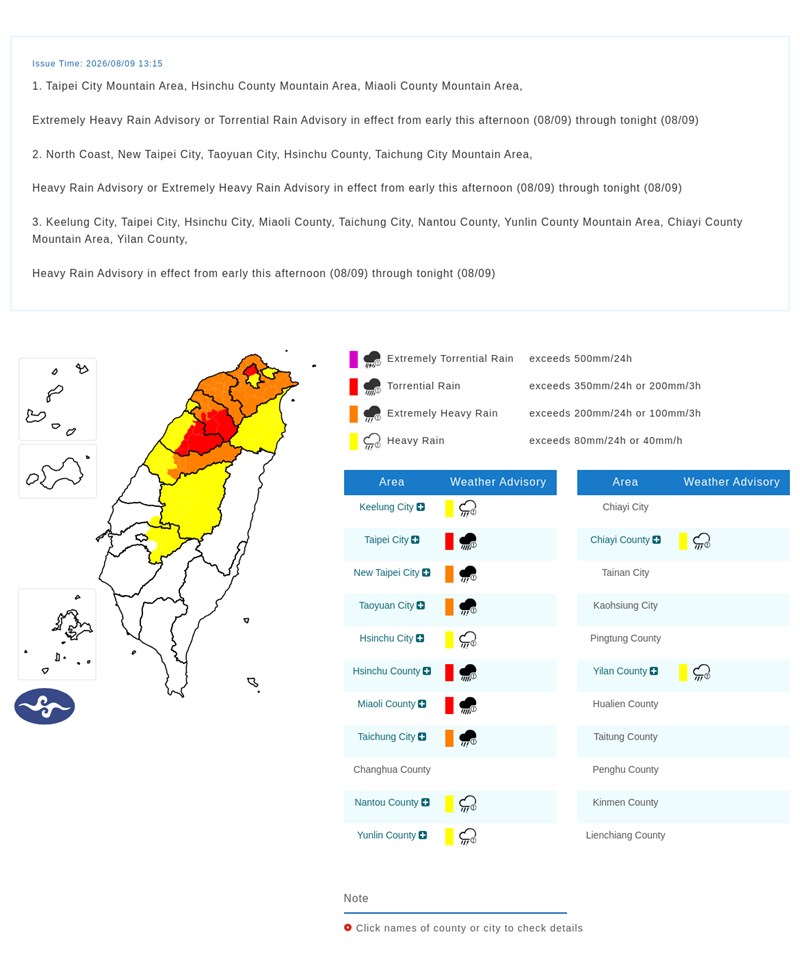
The CWA warned of torrential rain in mountainous areas of Taipei, Hsinchu and Miaoli, with heavy rain also forecast for areas north of Taichung and the north coast of Keelung.
Strong wind gusts of Beaufort scale force 8 (63-75 kph) or above are expected from Tainan northward, as well as in Pingtung, Yilan, Taitung, Penghu and Matsu.
Rainfall in northern Taiwan is forecast to ease from Sunday evening.
However, strengthened southwesterly winds combined with Dolphin's outer circulation are expected to bring heavy rain to southern Taiwan from Sunday night into Monday.
Localized heavy rain is also possible Monday afternoon in the greater Taipei area and northern mountain regions.
From Tuesday through Thursday, unstable weather associated with southwesterly winds and a low-pressure system is expected to bring intermittent rain to central and southern Taiwan, with afternoon thunderstorms elsewhere and localized heavy rain possible in northern mountain areas.
The CWA also warned of high waves along the coast of Keelung, New Taipei and Matsu, with waves exceeding three meters in waters north of Taiwan, the northern Taiwan Strait and eastern Taiwan.
With the high tide coinciding with the storm, low-lying coastal areas along Keelung's north coast and Yilan should remain vigilant for seawater inundation and localized flooding.
Separately, the CWA issued heavy rain advisories covering 12 cities and counties, warning of lightning, strong wind gusts, landslides, rockfalls, debris flows, swollen rivers and flooding in low-lying areas.
- Politics
Taiwan-donated patrol vessel handed to Philippine Coast Guard: Source
09/22/2026 09:13 PM - Business
Taiwan's export orders hit record high in August, surge over 70%
09/22/2026 08:15 PM - Culture
Migrant workers' award-winning photos exhibited at NTCH
09/22/2026 07:46 PM - Politics
Army unveils Stinger simulators, highlights counter-drone role
09/22/2026 07:39 PM - Politics
Labor minister says no 'downgrading' at China APEC meeting
09/22/2026 07:19 PM