Fung-Wong likely to weaken into tropical depression by Wednesday evening
Taipei, Nov. 12 (CNA) Tropical Storm Fung-Wong continued to weaken Wednesday, with its storm circle shrinking as it moved toward waters southwest of Taiwan, and is expected to pass over the Hengchun Peninsula before downgrading to a tropical depression by evening, according to the Central Weather Administration (CWA).
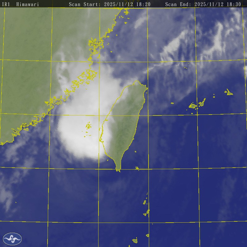
As of 6 p.m., the center of Fung-Wong was located 70 kilometers west-northwest of Cape Eluanbi, Taiwan's southernmost point, and moving northeast to east-northeast at a speed of 26 kilometers per hour (kph) slowly increasing to 41 kph.
It was carrying maximum sustained winds near its center of up to 65 kph and gusts of 90 kph, compared with 72 kph and 101 kph, respectively, recorded at around 10 a.m.
Based on the latest observations, the agency noted that Fung-Wong had weakened over the past few hours, with its storm circle contracting and having already extended over parts of southern Taiwan.
(Source: CWA)
The system still poses a threat to areas south of Tainan in southern Taiwan and Taitung in the east, the agency added.
The land warning remains in effect for Tainan, Kaohsiung, Pingtung and the Hengchun Peninsula as well as Taitung, while the sea warning covers the southern Taiwan Strait, waters southeast of Taiwan and the Bashi Channel.
CWA forecaster Chu Mei-lin (朱美霖) said the storm will likely continue moving along southwestern coastal waters, pass over the Hengchun Peninsula from late evening to night, and weaken into a tropical depression shortly after making landfall -- possibly even earlier than expected.
Due to the combined influence of Fung-Wong's outer circulation and strengthening northeasterly winds, waves 3 to 4 meters in height are expected along the coast, and up to 4 to 5 meters in the Taiwan Strait from Wednesday through Thursday, Chu said.
Strong wind advisories remain in place for most regions of Taiwan. From Wednesday afternoon through Thursday night, coastal areas will experience powerful gusts, while northern Taiwan is expected to see intensified winds as the northeasterly monsoon strengthens.
In terms of rainfall, intermittent showers are expected in southeastern Taiwan on Wednesday.
As Fung-Wong approaches, rainfall will increase in central and southern Taiwan during the evening, while northern Taiwan will see stronger northerly winds and heavier rain, particularly along the Keelung north coast and in Yilan's mountainous areas, Chu said.
She added that as Fung-Wong weakens or transitions into an extratropical system later Wednesday night, rain will persist in northern Taiwan before easing over the weekend as the northeasterly wind system weakens.
However, another surge of northesterly winds is forecast to arrive next Monday, bringing cooler temperatures and renewed rainfall, Chu added.
-
Society
Woman detained in alleged mercy killing of bedridden sister in Tainan
05/01/2026 09:24 PM -
Politics
'Be on Taiwan's side' on defense budget bill, Studeman tells KMT
05/01/2026 09:08 PM -
Society
Magnitude 6.1 earthquake shakes northeastern Taiwan
05/01/2026 08:53 PM -
Society
EVA Air eases eyewear, footwear rules for cabin crew
05/01/2026 07:01 PM -
Culture
Berlin school teaches Taiwanese perspectives on death
05/01/2026 06:43 PM