Taipei, Nov. 12 (CNA) Tropical Storm Fung-Wong continues to weaken as its path shifts southward, but it will still pose a serious threat to southern Taiwan Wednesday and bring heavy rain to central and southern Taiwan later in the day, the Central Weather Administration (CWA) said.
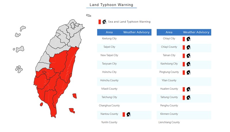
The eye of the storm is expected to pass over Taiwan's southern tip Wednesday evening, but the storm's circle had already enshrouded southern Taiwan in the morning, posing a threat to Kaohsiung and Tainan cities and Chiayi, Pingtung, Hualien and Taitung counties, the CWA said.

As of 10 a.m., the storm's eye was located about 140 kilometers west-southwest of Cape Eluanbi, Taiwan's southernmost tip, moving east-northeast at a speed of 16 kilometers per hour (kph) and packing maximum sustained winds of up to 72 kph and gusts of up to 101 kph, the CWA said.
CWA forecaster Chu Mei-lin (朱美霖) said eastern Taiwan will experience rain and the Keelung coast in the north may see heavy rain throughout Wednesday.
The rainfall in central and southern Taiwan will increase as the day progresses, she said, and the Greater Taipei area will see sporadic showers, with chances of localized heavy rain.
From Wednesday night to early Thursday morning, rainfall will further increase along the Keelung coast and in central and southern Taiwan, Chu said.
From Monday at midnight to Wednesday at 6 a.m., the CWA had recorded 1,061.5 millimeters (mm) of rainfall in Yilan's Dong'aoling, 752.5 mm in New Taipei's Dacukeng and 549 mm in Taipei's Qingtiangang.
-
Society
CTi reporter indicted for allegedly bribing soldiers to leak military secrets
05/06/2026 09:54 PM -
Business
Taiwan's forex reserves top US$600 billion amid market intervention
05/06/2026 08:32 PM -
Sports
Exhibition on Taiwan and the Asian Games opens in Tainan
05/06/2026 07:46 PM -
Society
Cosmetic surgery chain chairman detained over pinhole camera allegations
05/06/2026 07:35 PM -
Business
Taiwan shares end at fresh high, led by tech stocks after U.S. rally
05/06/2026 05:35 PM