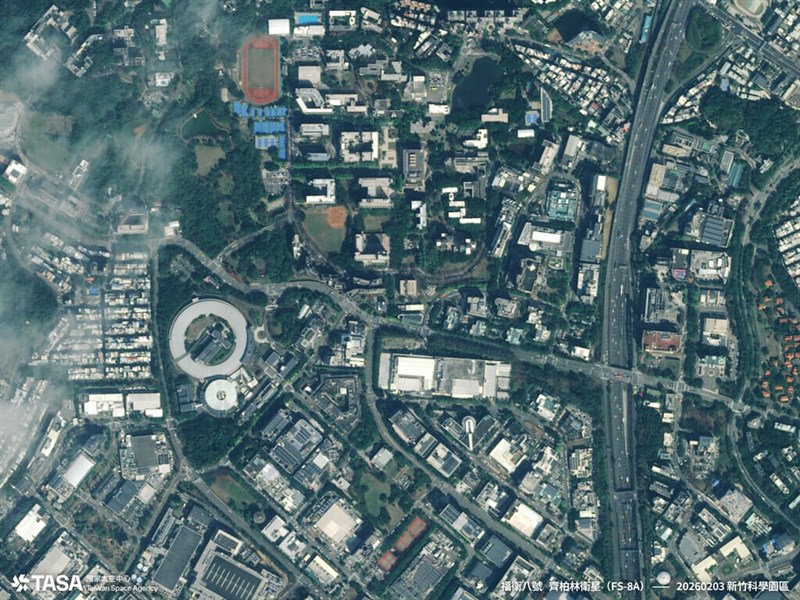
Taipei, Feb. 11 (CNA) The Taiwan Space Agency (TASA) on Wednesday released the first images from its Formosat-8A satellite, featuring high-resolution views of Hsinchu Science Park, Tainan's Anping District, Xingda Harbor in Kaohsiung, Tokyo's National Stadium and Barcelona Airport in Spain.
● INTERVIEW / Sharper eyes: Taiwan Formosat-8 to improve disaster relief, security
Formosat-8A, named the "Chi Po-lin Satellite" after the late Taiwanese documentary filmmaker Chi Po-lin (齊柏林), was launched on Nov. 29, 2025. It is designed to capture images at a 1-meter resolution, sharpenable to 0.7 meters after processing, surpassing the capabilities of its predecessor, Formosat-5, according to the agency.
It is the first of TASA's eight-satellite Formosat-8 constellation to be sent into orbit and is intended to help Taiwan monitor natural disasters and security threats, the agency said.
The images reveal detailed surface features, such as ocean layers and boat wakes, highlighting the satellite's ability to capture urban and natural landscapes, TASA added.
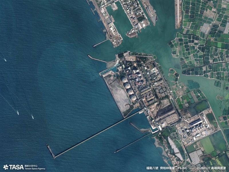
Unlike Formosat-5, which can only see blurred traffic flow, Formosat-8A can photograph airplanes and vehicles in detail, TASA said.
The next-generation satellite can also capture "red-edge" images sensitive to vegetation, which can be used for monitoring forests, water resources and agricultural conditions, according to TASA's Cynthia Liu (劉小菁), the Formosat-8 project lead.
TASA Director-General Wu Jong-shinn (吳宗信) said achieving 1-meter resolution took eight years of testing and development, adding that the Formosat-8A was made using 16 Taiwan-developed components.
Of the eight satellites in the Formosat-8 constellation, six will have 1-meter resolution capability and two will have 0.5-meter resolution, TASA said.
Once fully deployed in 2031, the constellation will provide global coverage and capture Taiwan three times a day, it added.
The second satellite, Formosat-8B, is scheduled to be sent into orbit aboard a SpaceX rocket by the end of the year.
- Society
New Taipei launches 4 new commuter bus routes over Danjiang Bridge
06/11/2026 07:48 PM - Politics
Coast guard expels Chinese vessels from Taiping Island restricted waters
06/11/2026 07:10 PM - Politics
Cabinet seeks tougher DUI penalties amid 'zombie vape' concerns
06/11/2026 06:51 PM - Business
Taiwan resumes pork exports with 1st Singapore shipment
06/11/2026 05:05 PM - Society
Taiwan's water supply stable through September: WRA
06/11/2026 04:53 PM