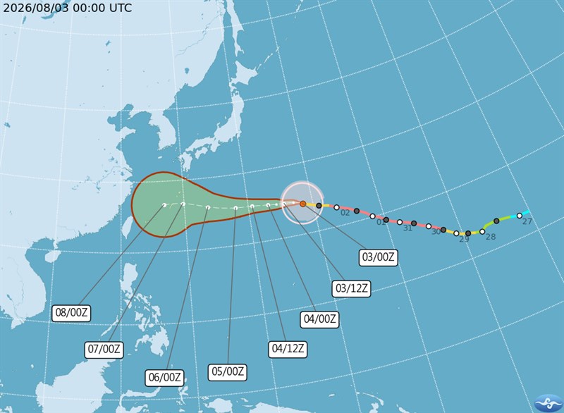
Taipei, Aug. 3 (CNA) Taiwan could issue a sea warning for Typhoon Dolphin as early as Friday afternoon if the storm maintains its current westward track, the Central Weather Administration (CWA) said Monday.
As of 8 a.m. Monday, the center of the typhoon was located about 2,720 kilometers east of Taipei and moving west at 23 kph, potentially bringing hazardous conditions to waters surrounding Taiwan by Saturday.
CWA forecaster Lin Ping-yu (林秉煜) said Dolphin is expected to reach waters south of the Ryukyu Islands around Saturday, but its track beyond that remains highly uncertain.
The typhoon could either continue moving westward or veer northward, Lin said. A westward track would bring greater impacts to Taiwan from its outer circulation, while an earlier northward turn would lessen the effects.
Although ocean heat content along Dolphin's westward path is relatively low, it remains sufficient to sustain the storm's current intensity, meaning it is unlikely to weaken rapidly, Lin said.
He said Dolphin is expected to remain a moderate typhoon or tropical storm while retaining a relatively large circulation.
A Friday afternoon sea warning, indicating that hazardous typhoon conditions are expected in waters surrounding Taiwan within 24 hours, cannot be ruled out if the storm continues on a westward track, Lin said.
If Dolphin turns northward, a sea warning may still be issued if the change in direction comes late and the storm's circulation does not shrink significantly, Lin said.
From Tuesday through Thursday, northeasterly winds are expected to bring isolated showers to northeastern Taiwan and mountainous areas around Greater Taipei, with localized heavy rain possible in mountain regions on Wednesday and Thursday afternoons.
As the typhoon approaches, winds are expected to shift to northerly or northwesterly from Friday through Sunday, with foehn winds possible in Yilan on Thursday and in Hualien and Taitung on Friday and Saturday.
Rainfall is expected to become more widespread in northern Taiwan and mountainous areas in the south over the weekend, Lin said.
The CWA also warned that long-period swells could begin affecting Taiwan's northeastern coast, eastern regions, the Hengchun Peninsula and the outlying county of Matsu starting Tuesday.
- Politics
Lai's WWII remarks warn of China's bid to reshape world order: Analysts
10/10/2026 07:27 PM - Business
Gasoline, diesel prices to remain unchanged next week: CPC
10/10/2026 06:09 PM - Politics
Opposition leaders criticize DPP, Lai in National Day remarks
10/10/2026 04:48 PM - Politics
Ex-President Tsai calls for deeper ties between Taiwan, Silicon Valley
10/10/2026 04:25 PM - Society
Filipino worker hospitalized, over 300 evacuated in Tainan dorm fire
10/10/2026 03:59 PM