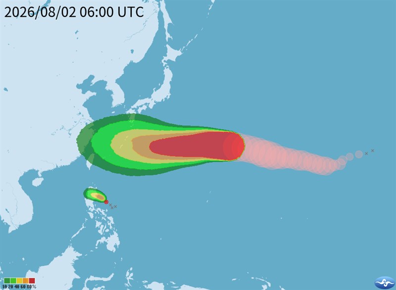
Taipei, Aug. 2 (CNA) Typhoon Dolphin could bring heavy rain to northern Taiwan later next week if it tracks closer to the island after passing the Ryukyu Islands, the Central Weather Administration (CWA) said Sunday.
The CWA said forecast models agree the storm will move toward the Ryukyu Islands through next Thursday, but diverge over its path after that.
One scenario has Typhoon Dolphin passing north of Taiwan, while another has it curving toward the Korean Peninsula if the Pacific high pressure system currently located over the East China Sea and Taiwan weakens.
Because of the uncertainty, it is still too early to determine whether Taiwan will issue a sea warning for the storm, CWA forecaster Liu Pei-teng (劉沛滕) said.
Liu said, meanwhile, that a tropical depression east of the Philippines could strengthen into Typhoon Kujira late Sunday or early Monday, but is expected to weaken again by Tuesday, with its moisture likely to be absorbed into Typhoon Dolphin.
Before the storm potentially affects Taiwan late in the week, the island will see typical summer weather through Tuesday, with hot conditions and isolated afternoon thunderstorms, Liu said.
Moisture is expected to increase starting later Tuesday, while Dolphin's outer circulation could begin affecting Taiwan on Friday.
The CWA has, for now, forecast localized heavy rain in northern Taiwan and the mountains of central Taiwan on Saturday and Sunday, with torrential rain possible in northern mountain areas.
- Politics
Shen holds 1st Taipei campaign motorcade; Chiang urges debate coordination
10/11/2026 08:39 PM - Society
Firefighters work to extinguish Miaoli trash dump fire
10/11/2026 07:58 PM - Politics
Lai's National Day speech steady, avoided provoking Beijing: Scholar
10/11/2026 06:53 PM - Society
Songshan: The ups and downs of Taipei's 'other airport'
10/11/2026 06:36 PM - Society
Philippines opens largest OFW service center in Taipei, eyes expansion
10/11/2026 06:11 PM