Taipei, June 10 (CNA) Fifteen photographic images sent from the Formosat-8A (FS-8A) satellite, the first in Taiwan's Formosat-8 constellation, were released by the Taiwan Space Agency (TASA) on Wednesday.
These high-resolution images showcase Taiwan's changing landscape, from its newest landmarks to sites that bear the marks of natural disasters.
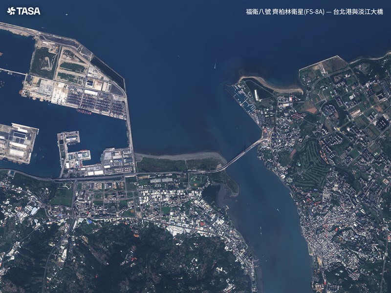
They include images of major harbors -- Taipei Port, Taichung Port and Kaohsiung Port -- where wharves, cargo ships and container yards can be seen in detail.
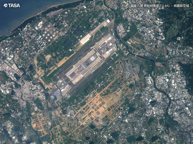
FS-8A also captured the neon-orange air bridge of Terminal 3 at Taoyuan International Airport, which is expected to open to the public in 2027, said TASA.
The satellite photographed a number of landmarks including the Danjiang Bridge in New Taipei, Taichung Mitsui Outlet Park, and the Great Harbor Bridge in Kaohsiung.
FS-8A also focused on the offshore islands of Penghu, Xiao Lanyu and Guishan Island, where turquoise shallows fade into the deep blue of the surrounding sea.
The images reveal intricate coastal contours and island terrain. In Penghu, the resolution is sharp enough to distinguish neatly arranged oyster racks and fishing nets stretching across the water.
Elsewhere, the photographs preserve traces of Taiwan's past. Subtle scars left by earthquakes are visible in an image of the Qingshui Cliffs in Hualien County, while another image captures the remains of Xiaolin Village in Kaohsiung, which was buried by a landslide during Typhoon Morakot in 2009.
TASA said the satellite can capture images at a resolution of 1 meter, which can be enhanced to 0.7 meters through processing, surpassing the imaging capabilities of its predecessor, Formosat-5.
Weather remains the biggest challenge for satellite imaging, the agency said, as cloud cover, particularly over northern and eastern Taiwan, can obscure the ground, as with an image of the Xiuguluan River in Hualien and Taitung Counties.
However, TASA said FS-8A's highest revisit rate could reach daily, allowing it to photograph the same location each day as it orbits Earth, increasing the likelihood of obtaining cloud-free images.
FS-8A, also known as "Chi Po-lin Satellite," was named after Taiwanese documentary filmmaker Chi Po-lin (齊柏林), who died in a helicopter crash on June 10, 2017. It is the first satellite in TASA's planned eight-satellite Formosat-8 constellation.
The satellite was launched on Nov. 29, 2025, using a SpaceX rocket, from a launch site in California. It began taking images in January 2026.
The eight satellites are expected to be in place by 2031 and will strengthen Taiwan's ability to monitor natural disasters and security threats, TASA said.
- Society
More camellia oil batches fail carcinogen test; sales suspended
07/27/2026 08:57 PM - Politics
Concerns over Chinese sea operations raised with Beijing, Taiwan says
07/27/2026 08:46 PM - Culture
Yu Kan-ping to receive Golden Horse lifetime achievement award
07/27/2026 08:38 PM - Business
Economic monitoring indicators stay red for 7th straight month
07/27/2026 08:18 PM - Society
TFDA releases findings on Central Union cooking oil contamination
07/27/2026 05:59 PM