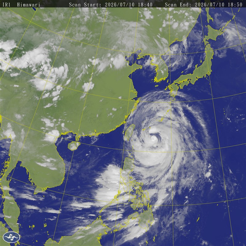
Taipei, July 10 (CNA) Typhoon Bavi is expected to have its strongest impact on Taiwan from Friday night through Saturday daytime, with its storm circle forecast to reach areas from New Taipei's northeast coast to Yilan and Hualien counties early Saturday, the Central Weather Administration (CWA) said Friday.
As of 6 p.m. Friday, the center of the typhoon was located about 590 kilometers east of Taiwan's southernmost tip at Eluanbi, moving northwest at 26 km per hour, according to the CWA.
The storm was packing maximum sustained winds of 155 kph near its center, with gusts reaching 191 kph. It had a storm radius of 380 km.
A land warning remains in effect for 14 cities and counties, covering areas from Changhua northward as well as eastern Taiwan and outlying Matsu Islands. Sea warnings cover waters north of Taiwan, the northern Taiwan Strait, waters off northeastern and southeastern Taiwan, and the Bashi Channel.
CWA Forecast Center official Lin Po-tung (林伯東) said the storm is forecast to pass north of Taiwan, and its storm circle is expected to shrink slightly as it approaches, meaning not every part of Taiwan will necessarily be covered by the storm circle.
However, Lin said the storm circle is expected to reach land early Saturday from New Taipei's northeast coast to Yilan and Hualien counties, while the typhoon itself is forecast to make its closest approach to Taiwan from around midday through Saturday evening.
The heaviest rainfall is expected from Friday night through Saturday daytime. Northern Taiwan and mountainous areas in central Taiwan and Yilan could see torrential rain, with the possibility of extremely torrential rainfall in some locations. Other parts of Taiwan are also likely to experience heavy rain as the storm's rainbands move across the island.
Strong winds are also expected to intensify. Coastal areas could see gusts of over 75 kph beginning Friday night, while inland areas may experience gusts of over 50 kph. During the day Saturday, the strongest winds are expected to spread further inland, including parts of northern Taiwan and Pingtung County.
Lin said the Taipei Basin is likely to experience its strongest winds from Saturday afternoon into the evening, with gusts of over 75 kph, while areas closer to the storm center along the north coast could see even stronger gusts exceeding 118 kph.
Wave height has already reached nearly 9 meters off Taiwan's east coast, the CWA said. Through Saturday evening, waves of 4-7 meters are forecast in waters north and east of Taiwan and in the northern Taiwan Strait, while seas near the typhoon's center could exceed 10 meters.
The CWA said the typhoon is expected to move toward China's coast by early Sunday. However, because the warning area also covers the Matsu Islands, the sea and land warnings for all Taiwan are unlikely to be lifted before early Sunday morning or later.
- Society
NIA seeks new logo for fund supporting new immigrants
10/19/2026 09:32 PM - Politics
Business groups back Taipower, CPC subsidies; scholars dissent
10/19/2026 09:31 PM - Society
Typhoon Champi to turn away from Taiwan, will still bring heavy rain
10/19/2026 07:53 PM - Society
Taiwan, Philippines sign animal husbandry research pact
10/19/2026 07:26 PM - Society
Workers rally in Taipei for pension reform, profit-sharing rules
10/19/2026 07:00 PM